NOTE: This study has now been updated with a newly released paper, available here:
http://www.worldagroforestry.org/global-tree-cover/global-sequestration-potential/index.html
Zomer, R.J., Neufeldt, H., Xu, J., Ahrends, A., Bossio, D.A., Trabucco, A., van Noordwijk, M., Wang, M., 2016. Global Tree Cover and Biomass Carbon on Agricultural Land: The contribution of agroforestry to global and national carbon budgets. Scientific Reports 6, 29987; doi: 10.1038/srep29987
Abstract
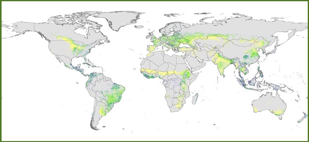
Agroforestry systems and tree cover on agricultural land make an important contribution to climate change mitigation, but are not systematically accounted for in either global carbon budgets or national carbon accounting. This paper assesses the role of trees on agricultural land and their significance for carbon sequestration at a global level, along with recent change trends. Remote sensing data show that in 2010, 43% of all agricultural land globally had at least 10% tree cover and that this has increased by 2% over the previous ten years. Combining geographically and bioclimatically stratified Intergovernmental Panel on Climate Change (IPCC) Tier 1 default estimates of carbon storage with this tree cover analysis, we estimated 45.3 PgC on agricultural land globally, with trees contributing >75%. Between 2000 and 2010 tree cover increased by 3.7%, resulting in an increase of >2 PgC (or 4.6%) of biomass carbon. On average, globally, biomass carbon increased from 20.4 to 21.4 tC ha-1. Regional and country-level variation in stocks and trends were mapped and tabulated globally, and for all countries. Brazil, Indonesia, China and India had the largest increases in biomass carbon stored on agricultural land, while Argentina, Myanmar, and Sierra Leone had the largest decreases.
Trees on Agricultural Land: Food Security, Adaptation, and Mitigation
The Global Tree Cover and Biomass Carbon on Agricultural Land analysis is part of on-going research focused on Trees on Agricultural Land: Food Security, Adaptation, and Mitigation, at the Center for Mountain Ecosystem Studies, a joint laboratory of the Kunming Institute of Botany (Chinese Academy of Sciences), and the World Agroforestry Centre (ICRAF).
This analysis investigated the geographic extent and socio-ecological characteristics of agroforestry globally, regionally, and nationally. The research, and the various geospatial analyses presented here, are a product primarily of research conducted by Dr. Robert Zomer, Wang Mingcheng and Prof. Xu Jianchu, at the Center for Mountain Ecosystem Studies, in collaboration with Dr. Antonio Trabucco, Euro-Mediterranean Center on Climate Change. Writing and further research input and support for this paper included collaboration with Dr Henry Neufeldt and Dr. Meine van Noordwijk, at the World Agroforestry Center, Dr. Deborah Bossio at the Center for Agriculture in the Tropics (CIAT), and Dr. Antje Ahrends, of the Royal Botanic Garden Edinburgh.
Global Tree Cover and Biomass Carbon on Agricultural Land Database- 2000-2010
The Geospatial Datasets providing the results of this analysis are available for download:
Data Download (GeoTiff format)
Data Manual: Tree Cover and Biomass Carbon on Agricultural Land Datasets
Various Maps in jpeg format are also available for download from the Map Gallery.
An overview of methods and results are described in the following set of publications:
Zomer, R.J., Neufeldt, H., Xu, J., Ahrends, A., Bossio, D.A., Trabucco, A., van Noordwijk, M., Wang, M. 2016. Global Tree Cover and Biomass Carbon on Agricultural Land: The contribution of agroforestry to global and national carbon budgets. Scientific Reports 6, 29987; doi: 10.1038/srep29987.
Zomer RJ, Trabucco A, Coe R and Place F. 2009. Trees on Farm: Analysis of Global Extent and Geographical Patterns of Agroforestry. ICRAF Working Paper no. 89. Nairobi, Kenya: World Agroforestry Centre http://www.worldagroforestry.org/downloads/Publications/PDFs/WP16263.PDF
Zomer, R.J., Trabucco, A., Coe, R., Place, F., van Noordwijk, M., Xu, J., 2014. Trees on farms: an update and reanalysis of agroforestry's global extent and socio-ecological characteristics. Working Paper 179. World Agroforestry Center, Bogor, Indonesia. doi:10.5716/ WP14064.PDF http://www.worldagroforestry.org/sites/default/files/WP89_text_only.pdf
Credits:
The research was partly supported by the National Key Basic Research Program of China (Grant No. 2014CB954100), and National Science Foundation China (Grant No. 31270524). Additional support was also provided from the CGIAR Research Program on Forests, Trees and Agroforestry; the CGIAR Research Program on Climate Change, Agriculture, and Food Security; and the Euro-Mediterranean Center on Climate Change.
We express our gratitude to the Carbon Dioxide Information Analysis Center (CDIAC), Oakridge National Laboratory and the authors of the “New IPCC Tier 1 Global Biomass Carbon Map”, to the Global Land Cover Facility at the University of Maryland and the authors of the MOD 44B MODIS Vegetation Continuous Fields datasets, and to the Global Land Cover 2000 Database, and the GADM for providing easy access online to the publically available global datasets used in this analysis, listed below:
Ruesch, A. & Gibbs, H. K. New IPCC Tier-1 Global Biomass Carbon Map for the Year 2000. (Oak Ridge National Laboratory, Oak Ridge, Tennessee, U.S., 2008). Available online from the Carbon Dioxide Information Analysis Center http://cdiac.ornl.gov/epubs/ndp/global_carbon/carbon_documentation.html
Hansen, M. C., DeFries, R. S. & Townshend, J. Global Percent Tree Cover at a Spatial Resolution of 500 Meters: First Results of the MODIS Vegetation Continuous Fields Algorithm. Earth Interactions 7, 10, 1-15, (2003). http://glcf.umd.edu/data/vcf/
DiMiceli, C. M. et al. Annual Global Automated MODIS Vegetation Continuous Fields (MOD44B) at 250 m Spatial Resolution for Data Years Beginning Day 65, 2000 to 2010, Collection 5, Percent Tree Cover. (University of Maryland, College Park, MD, USA., 2011) http://glcf.umd.edu/data/vcf/
Bartholomé, E. & Belward, A. S. GLC2000: a new approach to global land cover mapping from Earth observation data. International Journal of Remote Sensing 26, 1959–1977 (2005). doi:10.1080/01431160412331291297 http://www.un-spider.org/links-and-resources/data-sources/land-cover-map-glc2000-jrc
GADM, 2012. GADM database of global administrative areas, version 2.0[J]. 2012. http://www.gadm.org
The Centre for Mountain Ecosystem Studies (CMES) is an applied research laboratory jointly managed by the Kunming Institute of Botany (CAS) and the World Agroforestry Centre (ICRAF). Research is focused on mountain ecosystems, biodiversity, traditional communities, and development pressures impacting natural and cultural resources.
http://www.worldagroforestry.org/global-tree-cover/index.html