| You are currently reading our legacy website. You can view our current projects here: |
SOIL DEGRADATION RISK FACTORS
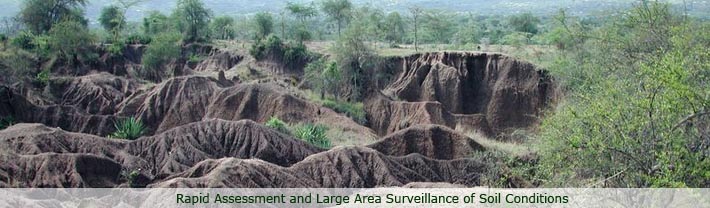
Based on the surveillance
protocol conducted in the River Nyando basin, and the spectral screening
tests developed for soil fertility condition and soil erosion, we were
able to analyze the relationships between land use and soil degradation
and identify tentative risk factors associated with soil degradation.
Prospective studies are required to verify these risk factors.
Land Cover Type
On average, over the basin, soil physical degradation (i.e. sheet and rill, gully, hardsetting) was strongly associated with sparse vegetation, whereas forest and wetlands were protective of soil degradation.
Vegetation cover
These results show that the critical factor for managing soil degradation is the amount of herbaceous ground cover!

Likelihood of observing soil
physical degradation in the Nyando basin under different vegetation
cover types
A graphical model showing conditional
relationships between soil physical degradation and herbaceous
ground cover
SOIL FERTILITY, SOIL EROSION AND AGRICULTURE
Soil erosion, in turn, appears to be the over-riding
risk factor for soil fertility change in the Nyando basin, whereas
agriculture has little impact on soil fertility once erosion is
controlled for in the analysis. Eroded soils have lost about half
of their capacity to retain nutrient cations and half of their carbon
content relative to stable soils.
Relationship between spectral indices of soil
fertility and soil erosion showing the absence of any interaction
with agriculture (Figure above and Table below)
| Variable |
Estimate |
SE |
t |
| Cut G/A |
-1.904 |
0.160 |
-11.92 |
| Cut A/P |
1.805 |
0.148 |
12.18 |
| Γs |
0.809 |
0.074 |
10.99 |
| Agriculture |
0.096 |
0.215 |
0.45 |
| Γs
Agriculture |
0.152 |
0.100 |
1.52 |
| Γs2 |
-0.065 |
0.009 |
-7.04 |
| Γs2
Agriculture |
0.032 |
0.037 |
0.87 |
The spectral library approach provides a
coherent framework for linking soil information with remote sensing
information for improved spatial prediction of soil functional capacity.
Remote sensing of soil properties directly from space platforms
is hampered by problems such as atmospheric interference, shade
and shadow effects, mixtures of materials within pixels, and variation
in soil moisture content. Studies on the effect of soil moisture
content on calibrations between soil functional attributes and soil
reflectance would help to evaluate the potential of reflectance
spectroscopy in the field. Future studies should explore approaches
that combine soil spectral libraries, and other geo-referenced information,
such as from digital terrain models and field observations, with
information from multi- and hyper-spectral remote sensing imagery
(e.g. Shepherd
and Walsh, 2002.)
|